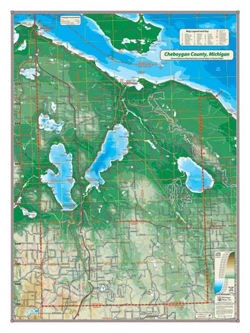
Navigable from Lake Huron to Crooked Lake, the core area of the historic Inland Waterway of Michigan (Cheboygan River watershed) lies at the heart of Cheboygan County, which contains three of the most massive lakes: Mullet, Burt and Black (in addition to Douglas Lake). The Sturgeon, Pigeon and Black Rivers originate in southern Cheboygan and flow north into Burt, Mullet and Black respectively. The cities of Cheboygan and Mackinaw City, and the towns of Indian River and Wolverine are also located in this county. The picturesque Huron shoreline tops off this beautiful map and includes most of Bois Blanc island (although the island is actually part of Mackinac County).
Item# – CHECOSM – 18″ x 24″ – $24.00 (Print)
Item# – CHECOSM-L – 18″ x 24″ – $36.00 (Laminated Print)
Item# – CHECOLG – 24″ x 32″ – $36.00 (Lg Print)
Item# – CHECOLG-L – 24″ x 32″ – $66.00 (Lg Laminated Print)
All county maps contain the following features:
- Land forms depicted in color-coded physical relief.
- Depth of large bodies of water depicted in shades of blue.
- Complete road grid down to local roads and some two-tracks.
- Snowmobile & ORV Trails, Rail-to-Trail, Non-Motorized Trails
- Parks, Trailheads, Boat & Kayak Launches, Historical Sites
- Other Points of Interest • Basic Statistics