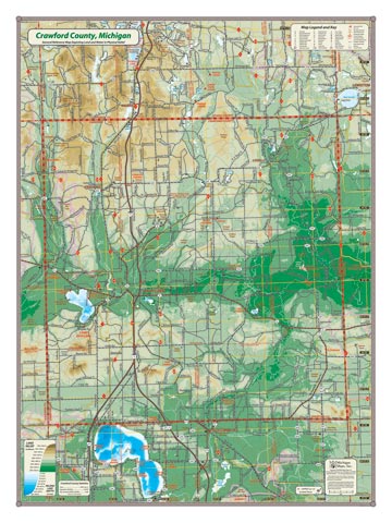
Crawford County sits in the middle of it all. Nestled in the center of the northern highlands, these hills are where two great river valleys originate: the Manistee River flowing to the west and the Au Sable river flowing to the east. This map also covers Higgins Lake which abuts the southern boundary of the county. The County includes the city of Grayling, and the towns of Frederic and Lovells. Grayling military base is located on the shore of Lake Margrethe.
Item# – CRWCOSM – 18″ x 24″ – $24.00 (Print)
Item# – CRWCOSM-L – 18″ x 24″ – $36.00 (Laminated Print)
Item# – CRWCOLG – 24″ x 32″ – $36.00 (Lg Print)
Item# – CRWCOLG-L – 24″ x 32″ – $66.00 (Lg Laminated Print)
All county maps contain the following features:
- Land forms depicted in color-coded physical relief.
- Depth of large bodies of water depicted in shades of blue.
- Complete road grid down to local roads and some two-tracks.
- Snowmobile & ORV Trails, Rail-to-Trail, Non-Motorized Trails
- Parks, Trailheads, Boat & Kayak Launches, Historical Sites
- Other Points of Interest • Basic Statistics