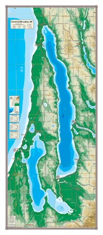
If you have ever stood on one of the ridges overlooking Torch Lake, its grandeur is unmistakable. The deepest and largest inland lake by volume in Michigan, it has an excitable personality that can turn from placid to suddenly churning with a simple shift in the wind—it’s big water—and some of the clearest, coldest water anywhere in the lower 48. If you’ve ever driven into Traverse City on M-72 from the east (Kalkaska), the expansive view of Skegemog Lake with the Skegemog Swamp Nature Preserve in the foreground (a piece of boreal forest reminiscent of northern Canada) is on your right as you summit the ridge (visible on the map). The emblematic view is truly unforgettable. Torch, Elk and Skegemog Lakes are fully inter-navigable—unless you have a very tall boat—with much to explore and many communities accessible from the water: Elk Rapids, Torch River, Alden, Clam River, Kewadin and Eastport.
All our lake maps include:
- Land forms depicted in color-coded physical relief.
- Depth of large bodies of water depicted in shades of blue.
- Complete public road grid right down to local roads.
- Parks, Boat Launches, Swimming, Preserves, Marinas
- Cultural Sites, Boundaries, Other Points of Interest
- Basic Statistics
Item# TORELK – 16″ x 36″ – $29.00 (Print)
Item# TORELK-L – 16″ x 36″ – $44.00 (Laminated Print)