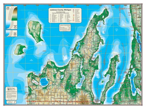
Certainly the most distinguishably shaped County in Michigan, the Leelanau County map could easily be titled the Leelanau Peninsula—surrounded by the water of Lake Michigan and encompassing the Manitou Islands. Old Mission Peninsula and Grand Traverse Bay round out the maritime coverage area. Looking inland, Glen Lake, Lime Lake, and North and South Lake Leelanau each are set in its own valley—surrounded by picturesque ridges. Leelanau County includes so many great places: the Sleeping Bear Dunes National Lakeshore, Leelanau State Park and Grand Traverse Lighthouse, Highway M-22; not to mention the quaint villages: Empire, Glen Arbor, Leland, Northport, Suttons Bay, Cedar and Maple City. Leelanau has so much to see.
Item# – LELCOSM – 24″ x 18″ – $24.00 (Print)
Item# – LELCOSM-L – 24″ x 18″ – $36.00 (Laminated Print)
Item# – LELCOLG – 32″ x 24″ – $36.00 (Lg Print)
Item# – LELCOLG-L – 32″ x 24″ – $66.00 (Lg Laminated Print)
All county maps contain the following features:
- Land forms depicted in color-coded physical relief.
- Depth of large bodies of water depicted in shades of blue.
- Complete road grid down to local roads and some two-tracks.
- Snowmobile & ORV Trails, Rail-to-Trail, Non-Motorized Trails
- Parks, Trailheads, Boat & Kayak Launches, Historical Sites
- Other Points of Interest • Basic Statistics