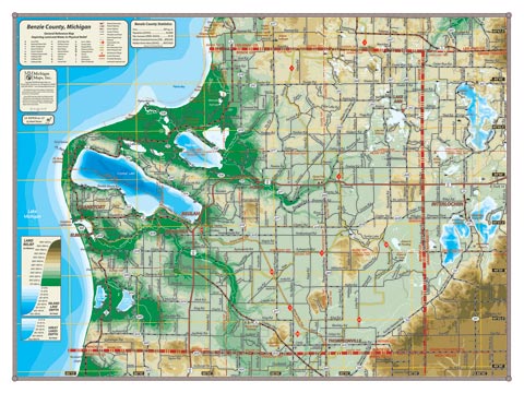
The smallest county in Michigan by area, yet Benzie County hosts some of the most emblematic natural areas in the State: the south unit of the Sleeping Bear Dunes National Lakeshore; the Platte River and Betsie River Valleys; Crystal, Platte, and Little Platte Lakes. The port of Frankfurt, and the towns of Lake Ann, Beulah, Benzonia and Thompsonville are all part of Benzie as well. The map also spans into western Grand Traverse County to include Long Lake, Green Lake, Duck Lake and the village of Interlochen.
Item# – BNZCOSM – 24″ x 18″ – $24.00 (Print)
Item# – BNZCOSM-L – 24″ x 18″ – $36.00 (Laminated Print)
Item# – BNZCOLG – 32″ x 24″ – $36.00 (Lg Print)
Item# – BNZCOLG-L – 32″ x 24″ – $66.00 (Lg Laminated Print)
All county maps contain the following features:
- Land forms depicted in color-coded physical relief.
- Depth of large bodies of water depicted in shades of blue.
- Complete road grid down to local roads and some two-tracks.
- Snowmobile & ORV Trails, Rail-to-Trail, Non-Motorized Trails
- Parks, Trailheads, Boat & Kayak Launches, Historical Sites
- Other Points of Interest • Basic Statistics