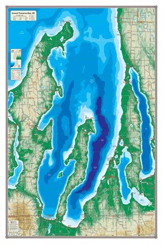
Grand Traverse Bay at the center of a frame is visually striking— and it’s also a fascinating study. What hath the glacier wrought to leave the extraordinary shape of the Old Mission Peninsula embraced by the West and East Arms of the bay. Torch and Elk Lake to the east, Lake Leelanau to the west, suggest that creation has an artistic flair—at least when painted by the Michigan Maps palette. Near the map center, the East Arm of Grand Traverse Bay reaches 600′ at its maximum depth in a deep ultramarine—you have to sail pretty far out into Lake Michigan before you come upon water that deep. Contemplate the mysteries of geology; or just admire the beautiful colors and your favorite place to anchor. All the bay-side communities are depicted as well: Northport, Omena, Peshawbetown, Suttons Bay, Traverse City, and Elk Rapids.
All our lake maps include:
- Land forms depicted in color-coded physical relief.
- Depth of large bodies of water depicted in shades of blue.
- Complete public road grid right down to local roads.
- Parks, Boat Launches, Swimming, Preserves, Marinas
- Cultural Sites, Boundaries, Other Points of Interest
- Basic Statistics
Item# – GRTRBY – 24″ x 36″ – $36.00 (Print)
Item# – GRTRBY-L – 24″ x 36″ – $66.00 (Laminated Print)