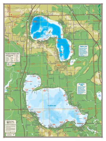
This map is the tale of two very different lakes. Houghton Lake, the largest lake by area in Michigan, is vast and relatively shallow—its deepest point a bit over 20’—and pleasantly warm water temperatures for swimming by midsummer. Higgins Lake reaches depths of over 130′ that keep its temps cool even through a hot summer. But they are both lakes that have hosted cottages for eons, and so there are a lot of tiny streets clustered around the lakes that we do a pretty good job of depicting (even the “Z” zones around Houghton Lake). The towns of Roscommon and Prudenville appear on this map. Together, these two lakes anchor a huge wetland ecosystem, and a careful reading of this map shows the complex creeks and drainage that connects them, and the swamp that keeps their waters pure—naturally.
All our lake maps include:
- Land forms depicted in color-coded physical relief.
- Depth of large bodies of water depicted in shades of blue.
- Complete public road grid right down to local roads.
- Parks, Boat Launches, Swimming, Preserves, Marinas
- Cultural Sites, Boundaries, Other Points of Interest
- Basic Statistics
Item# – HHLKSM – 18″ x 24″ – $24.00 (Print)
Item# – HHLKSM-L – 18″ x 24″ – $36.00 (Laminated Print)
Item# – HHLKLG – 24″ x 32″ – $36.00 (Print)
Item# – HHLKLG-L – 24″ x 32″ – $66.00 (Laminated Print)