General Reference Map Depicting
Land in Physical Relief
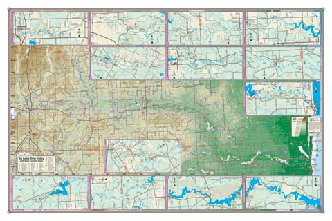
The legendary Au Sable River comes to life on this map of the entire valley of the river. Detailed physical relief allows one to see the expanse of the watershed and follow each twist and turn of the watercourse. The breakout maps show segments of the river corridor in greater detail: showing public access and land ownership. The North Branch and South Branch are also included, as are the still waters: Mio Dam Pond, Alcona Dam Pond, Loud Dam Pond, Five Channels Dam Pond, Cooke Dam Pond and Foote Dam Pond. Coverage: Grayling to Oscoda (Lake Huron), Lovell to Roscommon. A folding pocket map version of this map is also available to take with you on your paddling adventure (to see pocket map, CLICK HERE). A perfect map for the paddler or angler.
All our lake maps include:
- Land forms depicted in color-coded physical relief.
- Depth of large bodies of water depicted in shades of blue.
- Complete public road grid right down to local roads.
- Parks, Boat Launches, Swimming, Preserves, Marinas
- Cultural Sites, Boundaries, Other Points of Interest
- Basic Statistics
Item# ASRV – 36″ x 24″ – $36.00 (Print)
Item# ASRV-L – 36″ x 24 ” – $66.00 (Laminated Print)