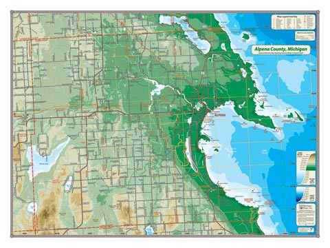
The great yawning mouth of Thunder Bay and the Lake Huron shoreline dominates the features of this dramatic map of Alpena County. The locations of many of the storied shipwrecks are identified in and around the Thunder Bay Bottomlands Preserve and the aptly named Misery Bay. In the west, the valley of the Thunder Bay River dominates the land features where it originates from the great swamps of the western lowlands and flows through the dammed reservoirs of Fletcher Pond and Lake Winyah.
Item# – ALPCOSM – 24″ x 18″ – $24.00 (Print)
Item# – ALPCOSM-L – 24″ x 18″ – $36.00 (Laminated Print)
Item# – ALPCOLG – 32″ x 24″ – $36.00 (Lg Print)
Item# – ALPCOLG-L – 32″ x 24 ” – $66.00 (Lg Laminated Print)
All county maps contain the following features:
- Land forms depicted in color-coded physical relief.
- Depth of large bodies of water depicted in shades of blue.
- Complete road grid down to local roads and some two-tracks.
- Snowmobile & ORV Trails, Rail-to-Trail, Non-Motorized Trails
- Parks, Trailheads, Boat & Kayak Launches, Historical Sites
- Other Points of Interest • Basic Statistics