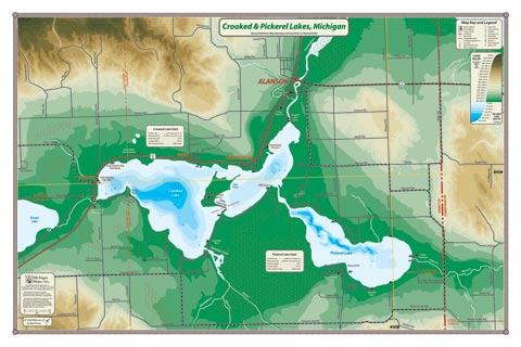
Located at the western end of the Inland Waterway in Emmet County, the many protective bays and points make Crooked and Pickerel Lakes a good alternative when the wind chases boaters off the bigger lakes. These lakes were a stop on the old railway route between Petoskey and Mackinaw City, and many of the old cottages still remain. The settlements of Conway and Oden, and the small town of Alanson are accessible from the water.
All our lake maps include:
- Land forms depicted in color-coded physical relief.
- Depth of large bodies of water depicted in shades of blue.
- Complete public road grid right down to local roads.
- Parks, Boat Launches, Swimming, Preserves, Marinas
- Cultural Sites, Boundaries, Other Points of Interest
- Basic Statistics
Item# – CRKLK – 24″ x 16″ – $24.00 (Print)
Item# – CRKLK-L – 24″ x 16″ – $36.00 (Laminated Print)