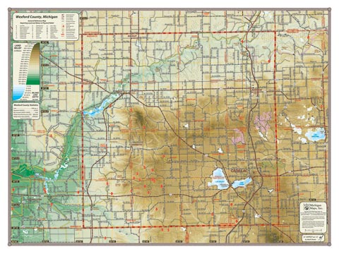
With the highest elevations in northwest Michigan and the deep Manistee River valley winding across its northern reaches, Wexford County contains some of the best raw material for a colorful relief map. Both the Manistee River reservoirs, Hodenpyl Dam Pond and Tippy Dam Pond appear on this map as does the Pine River. Lakes Mitchell and Cadillac, and the Hodenpyl Dam Pond. Like our other county maps, the Wexford map spans well into neighboring counties to points such as Lake Missaukee and Tippy Dam Pond.
Item# – WEXCOSM – 24″ x 18″
24″ x 18″ – $24.00 (Print)
24″ x 18″ – $36.00 (Laminated Print)
Item# – WEXCOLG – 32″ x 24″
32″ x 24″ – $36.00 (Print)
32″ x 24″ – $66.00 (Laminated Print)
All county maps contain the following features:
- Land forms depicted in color-coded physical relief.
- Depth of large bodies of water depicted in shades of blue.
- Complete road grid down to local roads and some two-tracks.
- Snowmobile & ORV Trails, Rail-to-Trail, Non-Motorized Trails
- Parks, Trailheads, Boat & Kayak Launches, Historical Sites
- Other Points of Interest • Basic Statistics